Learn · Continents · 8 minute read
Pangaea and the break-up
For a hundred million years almost all the land was one continent. Here is how it came apart and how we know.
Look at a map of the Atlantic and the coasts of South America and Africa seem made for each other. People noticed the likeness as soon as decent maps existed. The explanation took until the 20th century: they really were joined, in a single supercontinent that geologists call Pangaea, from the Greek for "all lands".
The man who said it first
In 1912 Alfred Wegener, a German scientist who studied the weather, published two articles arguing that the continents had once been joined and had drifted apart. He did not rely on the coastlines alone. The same fossil animals and plants turn up on coasts that are now oceans apart. Coal, which forms from swamp forests, is found in Antarctica. Fossil ferns called Glossopteris grow in rocks in what are now polar lands, and there are traces of old glaciers in the deserts of South Africa.
Most geologists rejected the idea. The fatal question was what force could possibly push a continent through solid rock. Wegener had no good answer. He froze to death in 1930 on an expedition across the Greenland ice cap, and the argument went on without him. The answer, sea-floor spreading and plate tectonics, came in the 1960s.
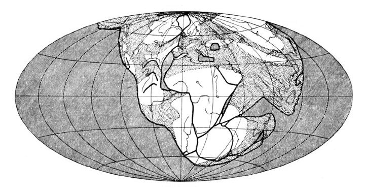
A fit made by computer
In 1965 Edward Bullard, Jim Everett and Alan Smith in Cambridge used a computer to fit the continents around the Atlantic together. Instead of the coastlines, which change as the sea rises and falls, they used the edge of the continental shelf, at a depth of about 900 m. They described each move as a turn about a single point on the globe, called a pole of rotation. The fit was remarkably good, and the idea of rigid plates turning about poles became the language of plate tectonics.
Breaking up
Pangaea began to break apart about 200 million years ago. It split first into two great landmasses: Laurasia in the north, which held North America, Europe and most of Asia, and Gondwana in the south, which held South America, Africa, Antarctica, India and Australia. Between them, to the east, lay an ocean called Tethys. Later Gondwana broke up too. Africa and South America began to pull apart about 140 million years ago, as rifts opened in the crust between them, and the South Atlantic was born.
The break-up never stopped. The Atlantic is still widening by a few centimetres a year, and India has crashed into Asia to raise the Himalaya.